The AGS digs deep to discover new knowledge about Alberta’s geology and energy resources, publishing thousands of maps, reports, datasets, interactive tools, and applications over its 100-year history. This information helps the public, Indigenous communities, industry, academia and policy makers understand Alberta’s geology, so they can be better informed about developments that matter to them.
Interest in renewable energy resources, like geothermal, is rising in Alberta. Geothermal energy captures the Earth’s underground heat, and under the right conditions this heat can be used for heating homes and offices, growing plants in greenhouses, or making electricity.
A conventional geothermal system targets deep, naturally permeable rock layers where hot water can easily flow from the rock into a well and be brought to the surface, where the heat can be extracted. Next-generation geothermal systems offer alternatives to relying on naturally permeable rock layers. Some systems create artificial fractures in the rock to facilitate water flow, while others use a "closed loop" design. In closed-loop systems, the well is sealed, and fluids pumped down are heated by the surrounding rocks. These fluids then flow back up through the well without directly contacting the rocks.
In Alberta, potential geothermal sites are distributed across the province, and the AGS – under a grant from the Government of Alberta – ventured to map them in a new atlas, which was publicly released in December 2024.
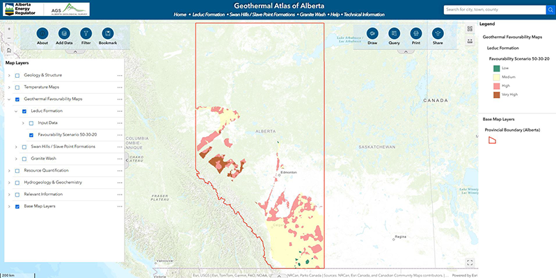
The Geothermal Atlas of Alberta is the first of its kind in Canada, as it is interactive and showcases geothermal potential of specific formations. Users can turn data layers on and off and calculate important geothermal summary statistics in areas that they define themselves. Geoscientists at the AGS leaned into their technical expertise and the wealth of geological data in Alberta from decades of oil and gas drilling to establish a method for predicting the geothermal potential beneath our feet. The result is a series of maps that display areas from “low” to “very high” geological favourability for conventional geothermal energy.
“We looked at the current research and came together to decide on a set of geological parameters and criteria to help us classify the conventional geothermal potential across various geological formations in Alberta,” Nevenka Nakevska, hydrogeologist and Geothermal Atlas project lead for the Emerging Resources team.
A Layered Approach to Geothermal Characterization
The AGS’ approach focuses primarily on three geological parameters: temperature, the presence of aquifers, and porosity of the rock.
Temperature
Temperature and temperature gradient are key to evaluating geothermal reservoirs, as they indicate how much heat is stored underground and how accessible it is for energy use. The geothermal gradient measures how quickly temperature increases with depth, and thus how deep a well needs to be drilled to reach temperatures effective for geothermal energy use. Guided by earlier research, AGS geoscientists created temperature grids and classified them based on potential uses:
- 1 – Low: less than 45 degrees Celsius (°C), can be used for storing and retrieving heat underground, known as geo-exchange.
- 2 – Medium: 45-90°C, low to medium potential for heating.
- 3 – High: 90-120°C, which is the minimum threshold for electrical power generation.
- 4 – Very high: greater than 120°C and has good potential for electrical power generation.
Aquifers
“Aquifers are underground rock or sediment layers that have water. Their presence – also known as aquifer indication – is important in conventional geothermal systems because they store and carry heat, which can be extracted and used in many ways,” Nevenka explains.
Data collected by the AER over time, including data from various oil and gas drilling activities, was used to identify aquifer characteristics. The AGS scrutinized the data to predict distribution, relative volume, and gross aquifer thickness, which helped to assess the presence of aquifers.
Porosity
For the third criteria, average rock porosity is multiplied by the net reservoir thickness, indicating volume of pore space in the host rock, or “porosity thickness”. Since the hot water is held within the pore spaces of the reservoir rock, it’s important to evaluate the pore volume and the reservoir’s ability to produce hot water.
“We looked at historical well logs to map porosity thickness,” Nevenka shares. “This information gave us clues about pore volume and how it’s distributed across the formations we studied.”
The larger the pore space, the more water a formation can hold. Additionally, porous rock is often more permeable. Therefore, geothermal potential is generally higher in formations that are porous because water can move to through the formation, into the well bore, and to the surface more easily.
Geothermal Favourability Maps
Overlaying these three parameters, AGS geoscientists created the first geothermal favourability maps for the Leduc Formation, the combined Swan Hills and Slave Point formations, and the Granite Wash.
Geothermal favourability refers to a region's potential for geothermal energy extraction based on geological, hydrogeological, and thermal characteristics. Beyond favourability, the Geothermal Atlas allows users to calculate and visualize how much heat energy is available in the subsurface within their region of choice, and how much electricity could potentially be generated from that heat.
“The maps in the Geothermal Atlas visualize areas within specific geological formations in Alberta with different degrees of geothermal potential. This helps people to understand where favourable conditions for conventional geothermal resource development may exist,” Nevenka concludes.
The Geothermal Atlas is a great first stop to interactively explore information on Alberta’s geothermal resources. Find the Geothermal Atlas and much more information about Alberta’s geology and resources on the AGS website.
Help Us Map New Frontiers
The Geothermal Atlas of Alberta is meant to be an evolving tool, so while this first version focuses on conventional geothermal, we're hard at work investigating Alberta's potential for next-generation geothermal resource types, and plan to update the Atlas with new information.
We’re also looking for other ways to improve the content and functionality of the Geothermal Atlas for future updates. Please help us by sharing your feedback about the application through a short survey. Your input will help guide future updates to the application.